Connecting the 5 Themes of Geography to History: A Vietnam War Museum Exhibit Project

In our unit on the Vietnam War, I wanted students to understand more than just the political timeline. I wanted them to see how geography—region, place, movement—shaped the war in real and lasting ways. So we tried something new: a museum exhibit project organized around the Five Themes of Geography.

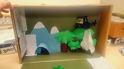
Students worked indepentendly or with a partner, researching and designing exhibits that connected the war to at least three of the five themes of Geography: Location, Place, Human-Environment Interaction, Movement, and Region. Each project needed to include one artifact or display per theme, plus a short written explanation for each artifact. Some chose slide decks, others used poster board or dioramas. One student built a diorama with a LEGO helicopter hovering over a dense jungle scene, with tiny soldiers navigating the terrain below—an attempt to show how U.S. military strategy was shaped by Vietnam’s landscape.

But what stood out most wasn’t the creativity—it was the thinking behind it.

One group mapped the Ho Chi Minh Trail and started asking questions about how supply routes worked when the U.S. had air superiority. Another pair created a display comparing two regions—North and South Vietnam—and added flags, photos, and quotes from leaders. Their write-up started with a basic explanation of political divisions, but by the end, they were asking whether the war had been inevitable once the country was split in half.

The conversation that followed was where the real learning happened:
“Did the U.S. understand the geography at all?”
“Is Agent Orange still affecting the land?”

The five themes gave students a structure, but it also opened up space for curiosity and deeper questions. And I noticed how often they circled back to human experiences—refugees, tunnels, the weight of the environment on both soldiers and civilians.

One student, after reading about the Cu Chi tunnels, asked if he could build a cutaway model for the Human-Environment Interaction theme. He wanted to show how people adapted, not just how they suffered. Another brought in a story her grandfather had shared—he’d served in Vietnam but never talked about it until recently. Her group included a short excerpt of his memory, printed on a card next to their display about Movement.

There was more movement, more discussion,  and more mess with a project like this—but it was productive mess. I observed students fact-checking timelines. Others were figuring out how to label terrain features in a way that would make sense to someone seeing it for the first time.

Standards were covered—students used maps, analyzed primary sources, explained cause and effect—but what I appreciated most was how the project encouraged them to slow down and think spatially. They weren’t just memorizing what happened; they were piecing together how and why it happened where it did.

We spent the last day presenting exhibits in a gallery walk. I encouraged students to leave sticky notes with questions or connections. Some wrote, “I didn’t know there was so much jungle,” or “This reminds me of the war in Ukraine now."

If you're planning a Vietnam War unit and looking for a way to bring in geography that feels meaningful—not just maps for the sake of maps—this project might be worth trying. It brings together research, analysis, creativity, and conversation in a way that traditional assessments often don’t. And the questions students ask along the way? They’re the kind that stay with them.

If you’d like a copy of this lesson, you can find it here.

You can find my Vietnam War Bundle here.                                                       


Comments

Popular posts from this blog

10 Creative One-Pager Ideas for Social Studies

10 Creative One-Pager Ideas for Social Studies As a social studies teacher, you understand that the subject is one of the most important aspects of education, and it is vital to keep your students engaged and motivated in their learning. One way to achieve this is through the use of one-pagers, a creative and visually appealing way to summarize information and showcase understanding. One-pagers offer a chance to showcase a student’s creativity, critical thinking skills, and grasp of the subject. In this blog post, we will explore ten creative one-pager ideas for social studies that will not only maximize your students’ learning but also spark their creativity and critical thinking skills. Why Use One-Pagers in Social Studies? One-pagers are an excellent way to get students engaged in the learning process. They are a creative and visually appealing way to summarize information and showcase understanding. By utilizing one-pagers, you can help your students to: Process information more ef...

Examples of Map Legends and Map Symbols (Plus Creative Tips and Project Ideas!)

Creative tips and projects for teaching students about legends (keys) on a map: 1. Create a scavenger hunt: Give students a map with a key and have them find different landmarks or features on the map. For example, you might ask them to find a park, a school, and a river. This is a fun way to get students engaged with maps and help them learn how to read legends. 2. Make your own map: Have students create their own maps of their school or neighborhood. They can include symbols for different features like buildings, parks, and roads. This is a great way to get students thinking about the different elements that go into making a map. 3. Use technology: There are many online tools that allow you to create custom maps with your own symbols and legends. Have students use these tools to create their own maps of their community or a fictional place. 4. Create a legend matching game: Create cards with different symbols from a map legend and have students match them to the correct definition. T...

Ripped Paper World Map Project - Middle or High School Geography

Earlier this week I presented my students with a challenge. Create a world map using construction paper, glue, and a sharpie. No scissors.  Students were not allowed to use any tools to cut out their continents. They had to tear their continents from construction paper. After their continents were ready, students were asked to label them and then glue them in place.  Each student's map needed a title, compass rose, key, symbols, Equator, and Prime Meridian, and all the continents and oceans had to be labeled. Most of my students had a blast creating their maps. Of course, a couple students were anxious; worried their continents wouldn't look nice. With some reassuring, they proceeded and did just fine.  This activity is a perfect back-to-school or sub-day activity. It required very little prep and materials. I let my students use any color construction paper they wanted as long as they selected two different colors.  The results were fantastic! Grab your copy of the ...